WV7252 : St Catherine's Bay from the air
St Catherine's Bay from the air
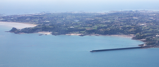
Viewed from the north-east on a flight from Gloucester to Jersey.
The huge breakwater is 600 metres long and was finished in 1855.
It was built as the northern breakwater of a projected "refuge" harbour for the Royal Navy.
The planned Southern breakwater was never completed.
On the left of the picture is the magnificent castle at Gorey and the Royal Bay of Grouville.
![Creative Commons Licence [Some Rights Reserved]](http://s0.geograph.org.gg/img/somerights20.gif)
year taken
2009
| Find out how to reuse this Image For example on your webpage, blog, a forum, or Wikipedia. | |||||
| Suggest an Update to this Image | Contact the contributor | ||||
- Grid Square
- WV7252, 5 images (more nearby)
- Photographer
- Bob Embleton (find more nearby)
- Image classification
- Supplemental image
- Date Taken
- Saturday, 8 August, 2009 (more nearby)
- Submitted
- Friday, 21 May, 2010
- Category
- Bay (more nearby)
- Subject Location
-
MGRS:
 WV 720 526 [100m precision]
WGS84: 49:13.3329N 2:0.6312W - Photographer Location
-
MGRS: WV 729 535
- View Direction
- Southwest (about 225 degrees)