WV6046 : Portelet Bay
Portelet Bay
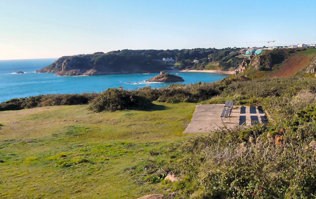
View from Noirmont Point across Portelet Bay, in the middle of which stands Janvrin Tower. It was built as a defense against French attack during the 1800s, but it stands above the tomb of a sailor called Philip Janvrin. On returning to the island from a trip to Nantes in the year 1721, Janvrin and his crew were not allowed to land, for fear that they might be infected with the plague that was afflicting the people of that area of France. They where ordered to stay in quarantine on their ship in the nearby Belcroute Bay. It's not known whether the crew were actually suffering from the plague, but sadly poor Janvrin died and his widow was still not allowed to bring his body ashore. Permission was finally given for his body to be interred on 'Ile au Guerdain', so that he would be within sight of his St. Brelade home.
![Creative Commons Licence [Some Rights Reserved]](http://s0.geograph.org.gg/img/somerights20.gif)
year taken
2010
| Find out how to reuse this Image For example on your webpage, blog, a forum, or Wikipedia. | |||||
| Suggest an Update to this Image | Contact the contributor | ||||
- Grid Square
- WV6046, 31 images (more nearby)
- Photographer
- Gerald England (find more nearby)
- Image classification
- Geograph
- Date Taken
- Monday, 4 October, 2010 (more nearby)
- Submitted
- Monday, 25 October, 2010
- Category
- Bay (more nearby)
- Subject Location
-
MGRS:
 WV 6028 4644 [10m precision]
WGS84: 49:10.0687N 2:10.3842W - Photographer Location
-
MGRS: WV 6050 4634
- View Direction
- West-northwest (about 292 degrees)