WV7150 : Gorey under its castle
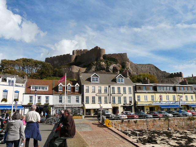
Gorey under its castle
The first recorded mention of Gorey Castle aka Mont Orgueil (its French name, meaning "pride") wasi n November 1212. Gorey Castle was a stronghold of English rule. In 1337 the French invaded, and the castle resisted siege. Blood flowed, but the castle did not fall. A second siege under French buccaneer Bertrand du Guesclin followed in July 1373, and the outer walls were breached. But the rock did not fall. The French finally occupied it in the fifteenth century, but through treachery not brute force. Sir Walter Raleigh was sent by Queen Elizabeth to tear down the old fort but sentiment won the day. Gorey Castle turned from sanctuary into prison. As the French Revolution cast its fanatical spell over Europe, the castle was used as a royalist base by d'Auvergne and his secret network. Then as Jersey sauntered into the sunlit uplands of the Victorian age, the castle retained its potency as a symbol of the island's proud loyalism and independence. Queen Victoria chose to visit Mount Orgueil with Prince Albert. She had a penchant for island castles. As Hitler's armies poured into Jersey and the swastikas flew over the fields of brown Jersey cows and sweet potatoes, Gorey Castle, as a prominent coastal fortified site, was absorbed into the machinery of the Third Reich. Concrete gun emplacements, bunkers and flak towers were added to the ancient walls. Today it is a tourist trap, but one with a unique sense of presence and power. You can experience something of the depth of the past, of the blood and glory of previous ages. Link
![Creative Commons Licence [Some Rights Reserved]](http://s0.geograph.org.gg/img/somerights20.gif)
year taken
2010
| Find out how to reuse this Image For example on your webpage, blog, a forum, or Wikipedia. | |||||
| Suggest an Update to this Image | Contact the contributor | ||||
- Grid Square
- WV7150, 69 images (more nearby)
- Photographer
- Gerald England (find more nearby)
- Image classification
- Geograph
- Date Taken
- Wednesday, 6 October, 2010 (more nearby)
- Submitted
- Wednesday, 3 November, 2010
- Category
- Castle (more nearby)
- Subject Location
-
MGRS:
 WV 7141 5011 [10m precision]
WGS84: 49:11.9775N 2:1.1854W - Photographer Location
-
MGRS: WV 7128 5013
- View Direction
- EAST (about 90 degrees)