WV4574 : La Coupee - from South
La Coupee - from South
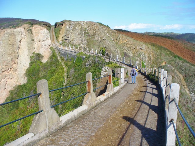
"Greater Sark and Little Sark to the south are connected by a narrow isthmus called La Coupée which is 300 feet (91 m) long and has a drop of 330 feet (100 m) on each side. Protective railings were erected in 1900; before then, children would crawl across on their hands and knees to avoid being blown over the edge. There is a narrow concrete road covering the entirety of the isthmus that was built in 1945 by German prisoners of war under the direction of the Royal Engineers".
Link Link
Link
Link
![Creative Commons Licence [Some Rights Reserved]](http://s0.geograph.org.gg/img/somerights20.gif)
year taken
2015
| Find out how to reuse this Image For example on your webpage, blog, a forum, or Wikipedia. | |||||
| Suggest an Update to this Image | Contact the contributor | ||||
- Grid Square
- WV4574, 15 images (more nearby)
- Photographer
- Colin Smith (find more nearby)
- Image classification
- Geograph
- Date Taken
- Thursday, 8 October, 2015 (more nearby)
- Submitted
- Thursday, 29 October, 2015
- Category
- Isthmus (more nearby)
- Subject Location
-
MGRS:
 WV 4598 7441 [10m precision]
WGS84: 49:25.2377N 2:21.9604W - Photographer Location
-
MGRS: WV 4596 7438
- View Direction
- Northeast (about 45 degrees)